

Bundaberg East Levee
The Bundaberg East Levee is a major investment in the flood resilience of Bundaberg.
The levee aims to:
- safeguard against a flood equivalent to the 2013 event or a 1% AEP (Annual Exceedance Probability) flood with additional clearance (freeboard).
- increase protection from a Burnett River flood within Bundaberg East, Bundaberg South, and the city centre
- create a resilient community that can recover faster from major flood events
- provide benefits for many people throughout the Bundaberg community
- create local jobs and business opportunities during construction.
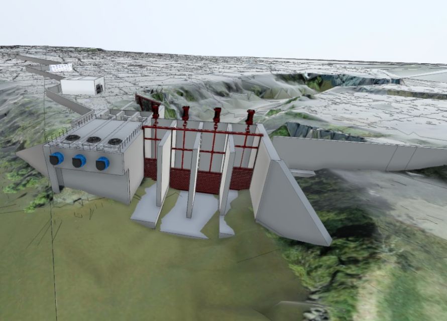
The concept design for the levee consists of approximately 1.57km of levee near the Burnett River’s southern bank with flood gates, flood doors and pump stations.

Flood protection
The January 2013 flood, caused by ex-Tropical Cyclone Oswald, was the highest Bundaberg flood on record.
The levee is designed to better protect Bundaberg East, Bundaberg South, and the city centre during a Burnett River flood event equal to the 2013 flood.
These areas are the first to flood when river heights reach +4.05m Australian Height Datum (AHD) at the Targo Street gauge. Properties in these neighbourhoods have been inundated 27 times in the last 150 years.
In North Bundaberg, inundation occurs when river heights reach +7m AHD at the Targo Street gauge. This has occurred eight times in the last 150 years.
Flood modelling
Modelling shows flood water inundation in January 2013, and how the levee would reduce flooding during a similar event.
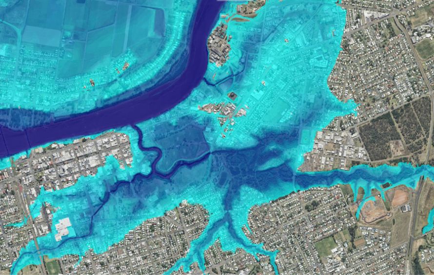
Modelling indicates that the levee location will have little impact on Burnett River flood levels, including in Bundaberg North.
Levee benefits
The levee is intended to foster a resilient community and enable Bundaberg to recover faster from major flood events. The levee means less damage, less clean-up and less disruption for some Bundaberg households and businesses, so that more people can get back to their homes and their jobs more quickly after floods.
Have your say
Public consultation is now open on the project’s Ministerial Infrastructure Designation (planning) application and closes on Monday 4 November 2024.
A MID is a planning process for delivering certain types of community supporting infrastructure. The process provides a streamlined way to:
- assess land use planning matters relating to the project proposal
- consider advice from other state agencies and technical experts
- gather and consider input from the community.
You can visit the Ministerial Infrastructure Designations public register to read the latest project reports and make a submission, on or before Monday 4 November 2024.
Follow these steps to make a submission:
- Visit the Ministerial Infrastructure Designation website
- Scroll down to the Public Register
- Select the “Requests open for consultation” tab
- Select MID-0524-0846-Bundaberg East Levee
- Read about the project
- Click the ‘Make a Submission’ button.
Levees
A levee is an artificial, raised embankment or structure built to:
- reduce the flow of water onto land
- protect parts of the floodplain from flooding, including properties, homes and businesses.
Levees can significantly reduce damage and allow communities to return to normal activity sooner after a flood event.
Levees are built to protect property, not people. Emergency planning and evacuation are still essential to protect communities.
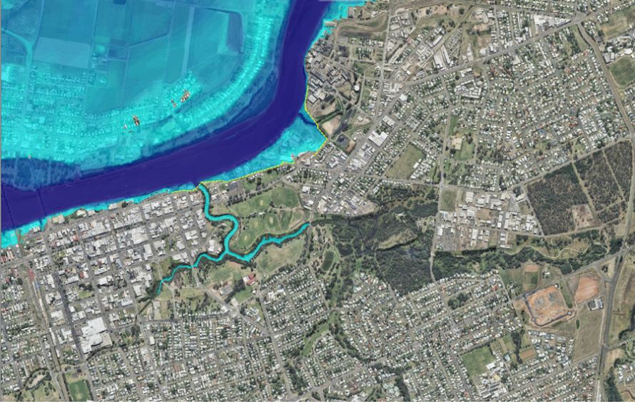
Levee Location

The Bundaberg East Levee will mainly run parallel to the southern bank of the Burnett River, from Walla Street in the Bundaberg city centre to the Millaquin Sugar Mill in Bundaberg East.
The alignment crosses two creeks: Saltwater Creek and a small unnamed creek near the Millaquin Sugar Mill, known locally as Distillery Creek.
The alignment design has been refined to address:
- vehicle and pedestrian access
- ground conditions (geotechnical) for foundations
- under and overground service locations.
We will need to acquire some land for the project. This will be limited to land parcels where the levee wall and associated infrastructure will be located. We will contact property owners directly.
Quay Street East
Under the proposed alignment, part of the levee wall will run down Quay Street East, with street access maintained for residents and businesses.
The south side of the street will be on the protected side of the levee and properties on the north side of Quay Street East will remain unprotected.
Neighbourhood access
The levee’s design will maintain movement through the neighbourhood in non-flood conditions. This includes access to roads, businesses and residences for pedestrians, cyclists and vehicles.
Openings in the levee wall – flood doors and flood gates – will provide this access.
In non-flood conditions, flood gates across the waterways at Saltwater Creek and Distillery Creek will remain open to allow water to flow. They can be closed during flood preparation.
Height
The Bundaberg East levee is being designed to withstand river heights seen in the January 2013 flood caused by ex-Tropical Cyclone Oswald. This was the highest flood level recorded in Bundaberg’s history and higher than a 1% annual exceedance probability (AEP) flood event.
The levee wall’s overall crest height will be +9.50m Australian height datum (AHD) (the height of a point above mean sea level). This will protect against a 1% AEP flood and provide approximately 300mm additional clearance (freeboard).
A flood with a 1% AEP has a one in one hundred chance of being exceeded in any one year. More background information about floods and estimating their chance of occurring is available here .
The levee will be built in two sections and will follow the contours of the land. A taller wall will be needed in low-lying areas, and a shorter wall on higher ground.
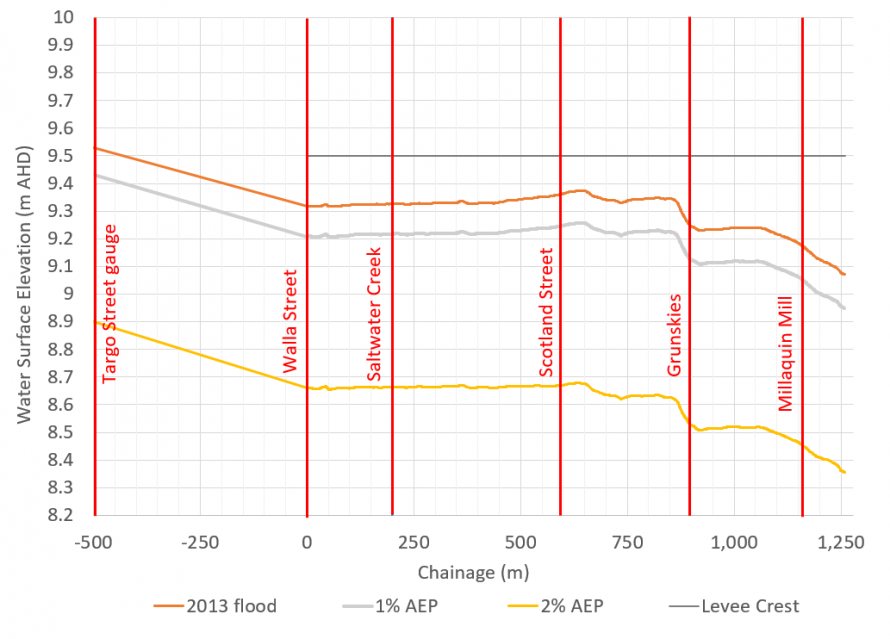
Wall height and the 2013 flood
The 2013 Bundaberg flood reached a peak of +9.53m AHD at the Targo Street flood gauge in Bundaberg Central, but the river height is different at different points.
At Saltwater Creek, which is further downstream, the 2013 flood event is modelled to have reached a peak height of +9.33m AHD. The levee wall height is higher than the 2013 flood heights in that section of the river, as shown below.
Modelling accuracy
The hydraulic computer model has been validated by comparing it against recorded flood levels at the Targo Street gauge and from survey records of the flood peak. This shows the computer model is working well and correlating closely with actual flood data recorded locally.
Appearance
The current design stage is focused on levee alignment and function.
We will consider:
- the importance of the levee performing its flood protection role
- the needs of local stakeholders, including adjacent and nearby property owners, residents and businesses
- opportunities to enhance the wall appearance.
Decisions about the wall’s features and appearance will be made during the design process with community input.
Project documents
- Project Update: November 2023 (PDF, 2916.42 KB)
- Background: Bundaberg East Levee Concept Engineering Report: March 2019 (PDF, 31890.77 KB)
Stay informed
Email BundabergEastLevee@epw.qld.gov.au with ‘Subscribe’ in the subject line, for project updates and community consultation opportunities.
The Bundaberg East Levee Project is jointly funded by the Australian and Queensland Governments and is supported by the Bundaberg Regional Council.